Pego on your website
Free to use, also commercially: copy the code under an image and paste it into your page. Each image links to hexplace and is updated with every data release.
Climate chart
Pego's average high and low temperature and rain days, month by month.
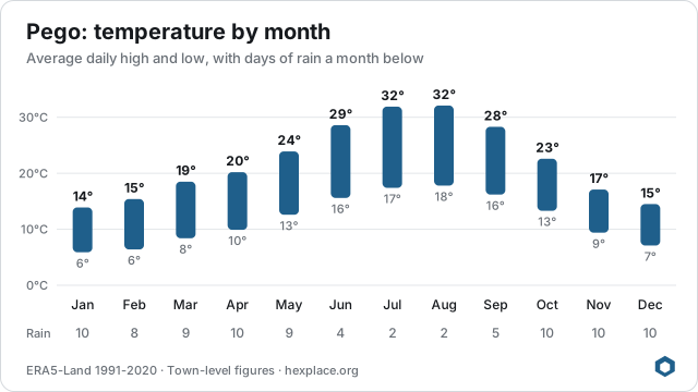
<a href="https://hexplace.org/portugal/pego/" title="Pego climate and town data (hexplace)"><img src="https://hexplace.org/chart/portugal/pego.svg" alt="Pego climate: average high and low temperature and rain days by month" width="640" height="360" style="max-width:100%;height:auto"></a>
Ranking badges
Pego ranks among the best in Portugal or its region on one measure. A badge links to its ranking and shows the current rank.
#1 in Oeste e Vale do Tejo: Hottest summers

<a href="https://hexplace.org/portugal/rankings/hottest-summers/" title="Pego, #1 in Oeste e Vale do Tejo: Hottest summers (hexplace)"><img src="https://hexplace.org/badge/portugal/hottest-summers/pego.svg?in=region" alt="Pego, #1 in Oeste e Vale do Tejo: Hottest summers" width="320" height="84"></a>
More to embed
A live town card or climate widget for Pego: open the embed builder. Developers can use the free API.
Please keep the link to hexplace: it is the one condition of the licence. Back to Pego